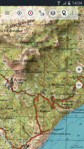
World-wide topographic maps.
Offroad Navigation App with worldwide topographic maps (mainly Russian General Staff). For many countries in Africa and Asia these maps still belong to the best available topomaps.
Available map layers:
• Topomaps worldwide (worldwide seamless coverage, mainly 1:100.000)
• ROSREESTR The Federal Service for State Registration, Cadastre and Cartography
•Googleマップ(衛星画像、道路および地形マップ)
• Open Street Maps (OSM Mapnik, Osmarender and Cloudemade Cyclemap)
• Bing Maps
• ESRI Maps
This app gives you similar mapping options as you might know from Garmin or Magellan GPS handhelds.
Main features for Outdoor-Navigation:
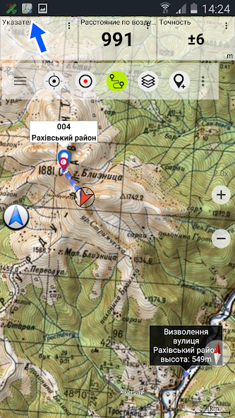
• Create and edit Waypoints
• GoTo-Waypoint-Navigation
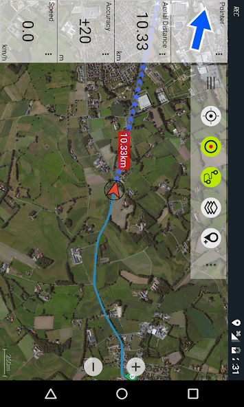
• Track Recording (with speed and elevation profile)
• Tripmaster with fields for odometer, average speed, bearing, elevation, etc.
• GPX,KML - Import
• Search (placenames, POIs, streets)
• Customizable datafields in Map View and Tripmaster (eg Speed, Distance, Compass, ...)
• Bulk-download of map tiles for OFFLINE USAGE (NOT in free version)
• Импорт Oziexplorer map format in OZF2 OZFX3 extension (NOT in free version)
• Импорт OpenStreetMaps in vector format (NOT in free version)
• Waypoint-/Track-Sharing (via eMail, Facebook, ..)
• and many more ...
ソビエト軍事地図は、オフロード旅行、冒険旅行、遠征に最適な移動マップアプリです。 You are planning cross country trips to Sahara desert or a trekking tour to the Himalayas ? With the Russian topos you have always a great alternative to other map sources. Beneath the good topography the maps include many small trails and unpaved roads that are missing in other map sets.
The Russian maps have additional English labels.
Attention: The Soviet Military Maps were created mainly in the 80ies and are less interesting for industrialized countries. Outside Africa and Asia you'll find the OSM / Google map layers more useful.
注:このアプリは、直接の「ターンバイターン」ナビゲーションを提供していませんが、選択したウェイポイントを使用すると、Googleナビゲーションに簡単に切り替えることができます。
LIMITATIONS OF THE FREE VERSION:
• Ads
•最大。 3 Waypoints
•最大。 3 Tracks
• No import of waypoints and tracks
• No Bulkdownload
• No Local City DB (Offline Search)
• No Hillshading Overlay
Please contact us if you have any questions, feature requests or bug reports regarding this app: [email protected]
Map coverage:
Scale 1:100.000 and 1:200.000 :
ヨーロッパ、アフガニスタン、アゼルバイジャン、ジョージア、日本、ヨルダン、ラトビア、リトアニア、カザフスタン、キルギスタン、モロッコ、モンゴル、パキスタン、ロシア、シリア、タジキスタン、トルコ、トルコメニスタン、ウクライン、ウッズベキスタン、ベラル
Scale 1:200.000 :
アフガニスタン、エジプト、アルジェリア、アンゴラ、アルゼンチン、アルメニア、アゼルバイジャン、バーレーン、バングラデシュ、ベラルーシ、ベニン、ブータン、ボリビア、ボツワナ、ブリティッシュバージン諸島、ブルガリア、ブルキナファソ、ブルマ、カンボディア、カメラ、カメラ、カメラ、イサンキューバ、キプロス、チェコ共和国、コンゴ博士(パート)、ジブチ、エリトリア、エストニア、エチオピア、フォークランド諸島、フィンランド、ガンビア、ジョージア、ガーナ、ギニア、ギニアビサウ、アイスランド、インド、インドネシア、イラン、イラ、イサク、イスラエル、ケネール、ケネールクウェート、キルギスタン、ラオス、ラトビア、レバノン、レソト、リベリア、リビア、リビア、リトアニア、マダガスカル、マラウイ、マレーシア、マリ、モーリタニア、モルドバ、モンゴル、モロッコ、モザンビーク、ナミビア、ネパール、ナイジェリア、韓国、パッカン、ナイジェリア、韓国、カタール、ルーマニア、ロシア、サウジアラビア、セネガル、シエラレオネ、シンガポール、スロバキア、ソマリア、南アフリカ、韓国、スペイン、スリランカ、スーダン、スヴァーバード、スワジランド、スウェーデン、シリア、台湾、タジスタン、タンザニア、タンザニア(パート)、タイ、タイ) Turkmenistan, Ukraine, United Arab Emirates, Uzbekistan, Vietnam, Western Sahara, Yemen, Zambia, Zimbabwe
スケール1:250.000(USGS、Geoscience Australia、CTIOのローカルマップ):
USA, Canada, Australia
Scale 1:500.000:
All other countries
これらの2024年11月のGenshin Impact Codes、5.1 LiveStream Codesで無料のPrimogems、Mora、Experienceなどを入手し、アクティブコードを引き換える方法を見つけてください。
Metaphor RefantazioのVanillaバージョンのプレイに飽きている場合は、これらの5つのMODを確認できます。
2024年のRobloxのThe Hauntイベントのためのあなたの提出に苦労していますか?ドレスを使用してキャプチャを作成するために感動するガイドをチェックしてください!
ドラゴンエイジのための私たちのウォークスルー:パズル、ボス、仲間、装備、ロマンスなどのガイドを備えたいくつかの便利なヒントとコツがあります。
ドラゴン時代にどの派factを選ぶべきですか:ベルガード?
Sea of Conquest:Pirate Warでいくつかのボーナスリソースをお探しですか?最新の船乗りの景品のために、これらのコードでカバーされています。
」弊社のウェブサイトでは、Russian Topo Maps の最新バージョンを簡単にダウンロードできます。登録やSMSは必要ありません! 「