Topo maps & aerial maps to plan hiking trips, outdoor & camping adventures
Explore like never before. MyTopo Maps is a mapping and trip planning app to organize all your outdoor and backroad adventures.
View more than 68,000 topo maps in US and Canada. Also, check out aerial, terrain, street and hybrid maps. Mark points, find places and store all your trip info on the Trip Cloud, a wireless service that allows you to access your trips on any device.
*** Note: This app is designed for the Android tablets. Got an Android phone? Try Trimble Outdoors Navigator, our in-the-field navigation app. ***
This app is BEST FOR: Scouting trails, exploring parks, planning outdoor vacations, viewing backcountry areas on topo maps and aerial photos, finding forest roads and campsites, preplanning hiking trails, snowshoeing routes, backcountry skiing sessions, camping and ATV offroad trips
------
** START WITH A GREAT MAP **
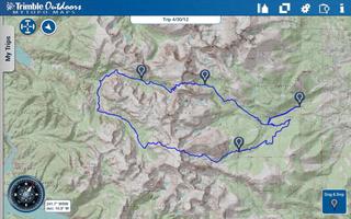
• View five different map types: streets, hybrid, aerial, topo and terrain.
• MyTopo Maps provides the most up-to-date topos maps available in the United States. We have enhanced more than 14,000 USGS quads with digital updates from the U.S. Forest Service and other map providers.
• Access more than 68,000 topo maps in US and Canada that are seamlessly stitched together for fast and easy viewing. Topos scales are 1:24K in the Lower 48, 1:63K in Alaska and 1:50K in Canada.
• See two maps at once. No single map type has all the essential details to plan a trip. So turn on Dual Map View and fade between two different map types.
• View aerial imagery from Bing maps.
• Upgrade to Pro to create map packs to store maps on your phone. This app allows you to save topos (MyTopo), aerials (Bing), streets (OSM), and terrain (OCM) map types on your phone.
** POWERFUL TRIP PLANNING TOOLS **
Place Search: Use our search to find more than 10 million places. Trails, peaks, lakes, rivers, ghost towns and more.
Ruler: Measure the distance between two points.
Smart Paste: Copy GPS coordinates from websites and instantly map their locations into MyTopo Maps.
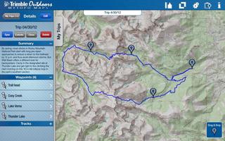
Waypoints: Drag waypoints on to the map. Name them and add descriptions.
Coordinates: Match your latitude/longitude or UTM coordinates to your paper map or GPS device. Supported map datum: WGS84 and NAD27.
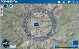
Digital Compass: Press the mini-compass to overlay a large digital compass on the map.
Custom Paper Map: Order a waterproof custom printed topo map or aerial image directly through our app with just a few taps of a button. Printed and shipped by MyTopo.com within 24 hours.
** SAVE TO THE TRIP CLOUD **
Register a free account to save your outdoor trips to our Trip Cloud. Benefits include:
• Store and backup unlimited trips. Never lose files again.
• Auto-sync trips between your computer, mobile phone and your Android tablet.
• Enhance trips planned in MyTopo Maps with more map tools at TrimbleOutdoors.com, including .gpx import, geotagged photos and videos, turn-by-turn routes and more. (requires membership)
• Open trips in our mobile navigation app, Trimble Outdoors Navigator. Learn more: http://get.it/trimbleoutdoors/8oUv
• Share trips with the Trimble Outdoors community or privately between outdoor friends.
** LEARN MORE **
Visit our website and check out thousands of trips submitted by the Trimble Outdoors community. Click over to: trimbleoutdoors.com.
-----
Note: This version of MyTopo Maps is designed and optimized for Android tablets. Please note your device must have a GPS chip to show your exact location on a map. Continued use of GPS running in the background can dramatically decrease battery life.
Get free Primogems, Mora, Experience, and more with these November 2024 Genshin Impact codes, 5.1 livestream codes, and find out how to redeem active codes.
If you are bored with playing the vanilla version of Metaphor ReFantazio, you can check out these five mods.
Struggling with your submissions for Roblox's The Haunt event in 2024? Check out our guide on using Dress to Impress to create your captures!
Our walkthrough for Dragon Age: The Veilguard with some handy tips and tricks, with guides for puzzles, bosses, companions, equipment, romance, and more!
Which faction should you pick in Dragon Age: The Veilguard?
Looking for some bonus resources in Sea of Conquest: Pirate War? We’ve got you covered with these codes for the latest seafaring freebies.
On our website, you can easily download the latest version of MyTopo Maps! No registration and SMS required!