NZ Topographic Maps, Nautical Charts and Aerial Imagery
Easy to use outdoor navigation app with most recent topographic maps of New Zealand, Cook Islands and Tokelau.
This app gives you similar mapping options as you might know from Garmin or Magellan GPS handhelds.
Main features for outdoor-navigation:
• Create and edit Waypoints
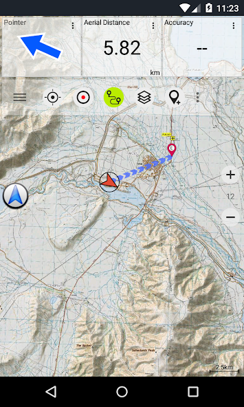
• GoTo-Waypoint-Navigation
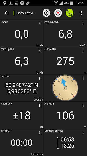
• Track Recording (with speed, elevation and accuracy profile)
• Tripmaster with fields for odometer, average speed, bearing, elevation, etc.
• GPX-Import / Export, KML-Export
• Search (placenames, POIs, streets)
• Customizable datafields in Map View and Tripmaster (eg Speed, Distance, Compass, ...)
• Share Waypoints, Tracks or Routes (via eMail, Facebook, ..)
• Use Coordinates in UTM, WGS84 or MGRS
• and many more ...
Available base map layers:
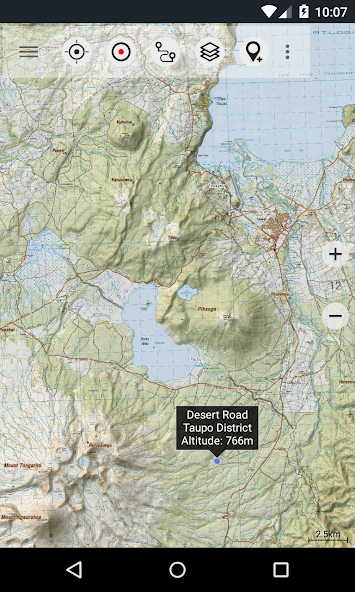
• Topomaps New Zealand (seamless coverage at scales 1:250.000 and 1:50.000)
• NZMariner (RNC Nautical Charts)
• LINZ Aerial Imagery
• Google Maps (Satellite images, Road- and Terrain-Map)
• Open Street Maps
• Bing Maps
• ESRI Maps
Overlay layers:
• Public Conservation Areas
• Open Hunting Areas
• DOC Camp Sites
• DOC Freedom Camping Restrictions
• DOC Huts
• DOC TRacks
• Taupo Trout Fishing District
• Hillshading
Use this navigation app for outdoor activities like hiking, biking, camping, climbing, riding, skiing, canoeing or offroad 4WD tours.
Preload FREE map data for areas without cell service. (Pro version only)
LIMITATIONS OF THE FREE VERSION:
• Ads
•สูงสุด 3 Waypoints
•สูงสุด 3 Tracks
• No Routes
• No import of waypoints and tracks
• No Bulkdownload
• No Local City DB (Offline Search)
The topographic maps were created by Land Information New Zealand (LINZ).
Topo50 is the official topographic map series used by New Zealand emergency services.
How topographic information is used
การวางแผนการป้องกัน: กองกำลังป้องกันของนิวซีแลนด์ใช้ข้อมูลภูมิประเทศสำหรับการวางแผนการออกกำลังกายทางทหารและการแลกเปลี่ยนข้อมูลกับพันธมิตรระหว่างประเทศ
สถานที่ตั้งและการกำหนดเส้นทาง: การค้นหาและช่วยเหลือการป้องกันรถพยาบาลบริการดับเพลิงตำรวจและหน่วยงานป้องกันพลเรือนใช้ข้อมูลภูมิประเทศในการวางแผนและสถานการณ์การดำเนินงานที่หลากหลายตั้งแต่ภัยธรรมชาติไปจนถึงการรักษาชุมชน Usage may involve mobile/field and control room situations, and the combination of topographic information with other data.
การจัดการที่ดิน: ข้อมูลภูมิประเทศถูกใช้โดยรัฐบาลท้องถิ่นเพื่อการวางแผนและการดำเนินงานในระดับภูมิภาคและโดย บริษัท พลังงานก๊าซและโทรคมนาคม
นอกจากนี้แผนที่ Linz ยังใช้เพื่อวัตถุประสงค์ที่หลากหลายโดยธุรกิจและหน่วยงานรัฐบาลเช่นกรมอนุรักษ์และโดยผู้ใช้เพื่อการพักผ่อนหย่อนใจเช่นคนเดินเล่นและนักท่องเที่ยว
All topographic maps have additional labels for better readability at higher zoom scales. Maps are rendered with Atlogis® hillshading to enhance topography.
Topo Map Coverage:
นิวซีแลนด์และหมู่เกาะ (Antipodes, Auckland, Bounty, Campbell, Chatham, Kermadec, Raoul, Snares และ Stewart Islands) ในระดับ 1: 50.000 และ 1: 250.000
Cook Islands (Aitutaki, Atiu, Mangaia, Manihiki, Mauke, Mitiaro, Palmerston, Penrhyn, Pukapuka, Rakahanga, Rarotonga, Suwarrow, Takute) ในระดับ 1: 25.000
Tokelau Islands (Atafu, Nukunonu, Fakaofo) at scale 1:25.000
Please send comments and feature requests to [email protected]
รับ primogems ฟรี, โมรา, ประสบการณ์และอื่น ๆ ด้วยรหัส Impact Genshin พฤศจิกายนปี 2567, รหัสการถ่ายทอดสด 5.1 รหัสและค้นหาวิธีการแลกรหัสที่ใช้งานอยู่
หากคุณเบื่อกับการเล่น Metaphor Refantazio เวอร์ชันวานิลลาคุณสามารถตรวจสอบ mod ทั้งห้านี้ได้
การดิ้นรนกับการส่งงานของคุณสำหรับเหตุการณ์หลอกหลอนของ Roblox ในปี 2567? ตรวจสอบคำแนะนำของเราเกี่ยวกับการใช้ชุดเพื่อสร้างความประทับใจในการสร้างการจับของคุณ!
คำแนะนำของเราสำหรับ Dragon Age: The Veilguard พร้อมเคล็ดลับและกลเม็ดที่มีประโยชน์พร้อมด้วยไกด์สำหรับปริศนา, ผู้บังคับบัญชา, สหาย, อุปกรณ์, ความรักและอื่น ๆ !
คุณควรเลือกกลุ่มใดในยุคมังกร: The Veilguard?
กำลังมองหาแหล่งโบนัสบางอย่างในทะเลแห่งการพิชิต: สงครามโจรสลัด? เราได้รับรหัสเหล่านี้สำหรับ Freebies การเดินเรือล่าสุด
คุณสามารถดาวน์โหลด New Zealand Topo Maps เวอร์ชันล่าสุดได้อย่างง่ายดายบนเว็บไซต์ของเรา! ไม่ต้องลงทะเบียนหรือส่ง SMS!