flight navigation & aeronautical charts
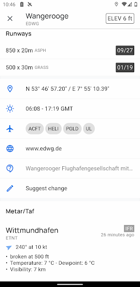
The integrated database includes airfields from Germany, Austria, Switzerland as well as BeNeLux, France, Italy, the Czech Republic and Poland and many other countries with information about name, frequency and runway data.
After the setup, VFRnav works completely offline and does not need an existing data connection for navigation at any time.
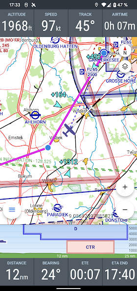
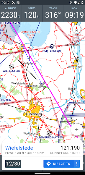
The integrated flight planning helps with route planning, the calculation of fuel and flight times and automatically provides information about flight weather (metar & taf) and notams enroute.
The flight log enables the digital recording of your flights. Thanks to the automatic flight time recording, all flights are automatically recorded. Tracks can be exported as KML files and sent by email. Flown routes can thus be easily displayed e.g. on Google Maps.
For high requirements, VFRnav can process position data from external GPS receivers via Wifi or Bluetooth. Traffic data is also processed and displayed directly on the map. VFRnav works with many FLARM and ADS-B devices. Stratux is also supported.
The development of VFRnav takes place in close contact with pilots in europe. In the current version 3, many ideas and suggestions have been implemented that have reached us by e-mail in the past few months. Many thanks at this point for all the feedback.
VFRnav is compatible with traffic data sources such as SafeSky, CCAS, Stratux, AT-01, FLARM, etc.
All functions of VFRnav can be tested without restrictions. If you like VFRnav, you can purchase a license for 49.95 €. You will receive all updates free of charge for one year. After 12 months have expired, the update period can be extended for just 29.80 €. However, VFRnav itself can run indefinitely.
By the way: The license is personal, but not device-specific. If you use several Android devices under the same Google account, the full version is available on all devices (maximum of three devices).
Note: For the map and airspace display, at least 200MB of free storage space must be available. Compatible with devices from Android 5. A minimum resolution of 480x800 pixels is recommended.
Disclaimer of liability: Please note that VFRnav is not an officially approved aid for flight preparation and execution. A guarantee for the correctness and completeness of the data is excluded. Please always check the data displayed with official aviation maps.
Get free Primogems, Mora, Experience, and more with these November 2024 Genshin Impact codes, 5.1 livestream codes, and find out how to redeem active codes.
If you are bored with playing the vanilla version of Metaphor ReFantazio, you can check out these five mods.
Struggling with your submissions for Roblox's The Haunt event in 2024? Check out our guide on using Dress to Impress to create your captures!
Our walkthrough for Dragon Age: The Veilguard with some handy tips and tricks, with guides for puzzles, bosses, companions, equipment, romance, and more!
Which faction should you pick in Dragon Age: The Veilguard?
Looking for some bonus resources in Sea of Conquest: Pirate War? We’ve got you covered with these codes for the latest seafaring freebies.
On our website, you can easily download the latest version of VFRnav! No registration and SMS required!